Showing posts with label Archaeological sites. Show all posts

Saturday, September 17, 2011

Remains of an ancient Greek colony were found in an island near Sozopol in Bulgaria


Archaeologists brought to light the ruins of an ancient Greek settleement after excavations they conducted at the little island of St. Kirik in the Black sea.Sozopolis is the modern name for the ancient settlement of Apollonia.Apollonia which is one of the oldest ancient Greek colonies was founded by Milesians at the 7th century BC.

Apollonia located south west


The head archaeologist of the excavations  Cristina Panayotovna  stated that the findings of the excavation could reveal the structure of a typical Greek Black sea colony.The ruins of the buildings proved the existence of an organised urban society.The building that were found were a metallurgical workshop and two streets(one of them led to Apollonia)  ,Among the findings there were also tools for fishing, tools for cloth production,religious pottery and religious idols made of clay.


Panayotovna's team will return for excavations in October. During the summer a Bulgarian-French team of archaeologists made excavations at the outskirts of Apollonia focusing on the remains of a mansion were they found a treasure of ancient coins.


source: to vima newspaper, translation made by me.

Friday, August 19, 2011

The modern Isthmus of Corinth and the ancient Diolkos

DSC02285
The Isthmus of Corinth

An Isthmus is defined as  a narrow strip of land connecting two larger land areas usually with waterforms on either side.The Isthmus of Corinth was an important crossroad of the ancient world. It was the land bridge that connected Peloponnese with mainland Greece. 


The ancient Greeks and later the Romans and Byzantines attempted numerous times to fortify this narrow strip.During the Persian wars there was a plan for the Greeks to build wooden walls along the Isthmus and wait for the Persians there.


Herodotus argued that a wall on Isthmus was useless if the defender couldn't control the seas. Likely he took the historic example of the Dorian invasion in the Mycenean Peloponnese in which the Dorians didn't invade through Isthmus but instead they used sea transports.


Remains of the examilion wall


In the 5th century, the Eastern Roman empire built a wall in Isthmus to stop the invading Visigoths. The wall had two gates and it was considered the biggest building in Greece at its time. It was called examilion(six miles) maybe because its length was 6 miles. The material used for the buiding were marbles from the nearby temples of Poseidon and Hera in Isthmus and Perahora.


During emperor Justinian more towers were added to increase the effectiveness of the defences.
Herodotus seemed to be right about his opinions on the wall cause during the Slavic invasions the Slavs just went around the wall through the sea and invaded Peloponnese.


Later many other Byzantine emperors tried to repair the walls but all these attempts were futile when the gunpowder technology was mastered by the Ottoman armies.


The canal of Corinth


The concept of cutting a canal through the Corinth Isthmus to link the Ionian and Aegean seas was first proposed by Periander tyrrant of Corinth at the end of the 7th century BC. The magnitude of the task defeated him so he opted instead to build a diolkos across which sailors dragged ships from the Ionian port of ancient Corinth called Lechaion to Cenchreai the Aegean port(http://akrokorinthos.blogspot.com/2009/08/kechries.html) and vice versa.

Later many great persons like Alexander the Great and Caligula had the "canal idea" but it was during Nero in 67 AD that diggings started for the opening of the canal.  6000 Jewish prisoners were working on this project  but unfortunately for Nero it was halted because of Gaulish invasions.

The canal was ultimately completed some decades after the creation of the modern Greek state in the 19th century by a French company(1883-1893). The architects were Istvan Turr and Bela Gerster, both of them Hungarians. This made Peloponnese officially an island(the ancient Greeks mistakenly thought it was already an island Peloponnesos  Pelops= an ancient Greek King  and  nesos=island

The canal is 6 kilometers long and 23 meters wide(79 feet).The land sides rise 90 meters above the water.

 An estimated 11,000 ships per year travel through the waterway, most of them full of tourists. When the canal was originally built it was meant to allow all boats to pass through, but unfortunately due to its narrow width of 24 metres it is too narrow for modern day ships that are built too large to pass through. One main bridge crosses overhead while at both ends seashore roads cross using submersible bridges that are lowered to allow ships to pass through. Sometimes, when the bridge rises, fish are caught and come up with the bridge as kids run to collect them.

The first strike in the modern Greek history

The workers in the Corinth canal opening were the first ones to organise a strike.


90 years after the creation of a modern Greek state in 1888 the workers in the Isthmus of Corinth declared a strike demanding a fair way of calculating their working time.This resulted a new agreement between the workers and the contractors about estimating the salaries and working times in order to avoid exploitation and fraud.


Sunday, April 17, 2011

Greek presence in Libya (1rst part: The founding of Cyrene)

Cyrenean coin that depicts Ammon Zeus.
Cyrenaica was  colonized by the Greeks from the 7th century BCE. The oldest and most important foundation was that of Cyrene, established in 631 BCE by colonists from the island Thera, who had left the island because of a famine.


The Greek Pentapolis in the Cyrenean penisula.
Nevertheless various attempts have been made by scholars to prove that the settlement of Greeks of Thera in Libya was preceded by an older wave of Greek settlers. Allusions to this older colonization have been found in the verses of Pindar who tells of the encounter of settlers of Thera with the Antenorids who had come to Libya with Helen after the capture of Troy.Various philologists have sought to attribute distinctive elements  surviving in the Cyrenean dialect to an earlier stratum of Greek speaking settlers .According to Schachermeier Achaeans who had reached Libya by way of Cyrene joined the alliance of Libyan tribes to attack Egypt.


The colonization of Libya by Theran pioneers was among the latest colonizing projects of the ancient Greeks and was an isolated phenomenon.It was a specific situation created by the overpopulation of the Greek island of Thera(modern Santorini) 


According to the Theran tradition Grinnos the king of Thera went to the Oracle of Delphi with Battus son of Polymnestos to consult the Oracle. Pythia told them to found a colony in Libya.The Thereans paid a Cretan fisher named Corobius to come with them to Thera and shortly after, with a small party and Corobius as pilot, they set sail for Libya. The men landed on Platea and left Corobius there with enough supplies for a short while and then returned to their island bringing good news about finding the new colony. Corobius agreed to wait on Platea for a length of time, however his supplies began to run out. Luckily, a Samian vessel bound for Egypt under command of Colaeus was re-routed to Platea due to poor weather conditions. The crew gave Corobius enough food to last one year. Colaeus and his crew were anxious to reach their destination as easterly winds prevented them to travel to Egypt and they were driven as west as the Pillar of Hercules (modern Strait of Gibraltar). By fortunately they landed at the wealthy trading post of  Tartessus.


The route of the Theran colonists.


A group of settlers was formed consisting of one brother from every household of Thera with sons,under the leadership of Battus. Eventually two ships set out for Plataea. After a two years stay on Plataea and another appeal to Delphi the settlers moved to the mainland and passed to Aziris somewhere westwards remaining there sic years. Finally they were led more westwards by natives to Cyrene. Today the historians claim that the colonization of Cyrenaica was a part of a more complex process.There are indications that there was Cretan Samian and Rhodian involvement in the colonization process.


The fountain of Apollo


It is generally believed that the city of Cyrene was founded in 631 BC.The name comes from a fountain called "Cyre", which was believed to have been consecrated to  Apollo. In addition to naming the settlement, Battus made all the colonists swear an oath. There is an inscription dated from the 4th century BC, which claims to contain the original oath. It may be assumed that the small greek settlement found its first foothold on the Acropolis(defensive hill) of Cyrene and the community's weakness and isolation compelled its pioneers to find an accommodation with the Libyan natives.Since the colonists were all men they married Libyan women. Some scholars have believed that Battus is a Libyan word mainly since the first recorded king of Cyrene had a different name(Aristoteles). Herodotus mentions that Battus meant "king" in Libyan.Although, other scholars believe that the personal name Battus became synonym of king for the Libyans.


Herodotus  emphasizes on the mutual influence between the greeks of Cyrene and the Libyan tribe Asbystae who taught them to drive the four horse chariot and themselves adopted Greek customs. However other sources mention conflicts between the Greek settlers and their Libyan neighbors.


Battus died in 600 BC and was worshipped as a  heroic figure by his subjects. His grave is near the marketplace which joins the road he ordered the construction of, leading to the temple of Apollo. A statue of Battus was dedicated at Delphi, by the subjects of Cyrene. He is represented riding in a chariot driven by the nymph of Cyrene, with a figure symbolising Libya in the act of crowning him King .His dynasty is known as The Battiad dynasty. He was succeeded by his son  Arcesilaus I.Although little is known of Battus' reign, he appeared to govern with mildness and moderation.  

sources: Shimon Applebaum , Greeks and Jews in Ancient Cyrene  and Wikipedia

Thursday, April 7, 2011

Olynthos(an account of my visit there)

In Olynthos 

Olynthos is not among the famous archaeological sites where tourists from the whole world would come to visit in fact even in antiquity it wasn't a very important city except for a very short period. Its location in Northern Greece makes it less known since these areas are preferred mainly by Balkan or Russian tourists rather than Western tourists .

the ruins of Olynthos
Some six years ago i was in Chalcidice for vacation. Chalkidice is the main holiday destination for Northern Greeks and for Balkan tourists who visit Greece. Its two legs(if you see the map Chalcidice has three penisulas that look like legs. Although one of them is inaccessible for women it's called holy mountain and is full of monasteres) have nothing less to offer than any of the famous Greek islands.From an archaeological perspective Chalcidice has to offer some interesting sights. Except Olynthus there's also ancient Potidaia the second biggest town of Chalcidice after Olynthos in antiquity and Stageira the town where Aristotle grew up.There is also anthropological interest the area.In a cave with depth of 300m. called petralona excavations have revealed the presence of human homo erectus dating some thousand years ago.

Olynthos used to be a human settlement since the bronze age. According to Greek mythology Olynthos was one of the numerous sons of Hercules. However historically it is mentioned that in the 7th century BC it was inhabited by  Thracians. After the Persian wars Greek colonists from nearby areas made Olynthos a greek city.It was not until the 4rth century that the city came to prominence. Ironically in the same century at the height of its power it was looted and razed by King Philip of Macedon.


The archaeological sight is a bit difficult to find. It is in the inland of Chalcidice and if you don't know the area i suggest you to have a gps or a map with you. When i went there i didn't have to pay a ticket but surely there is a symbolic price.Entering the sight you will see a little building which operates as a litle museum. Inside it there are some exhibits from the main site. I recommend you to bring  with you a bottle of water cause all the refreshments at the nearby shop are expensive and especially if are visiting at summer the sun dehydrates you quickly.A summer hat would also be a good addition to your sun protection.


The main site is a little far from the entrance. You must walk at least 500 metres and ascend a small hill(most ancient greek sites are located on plateaus where they could be better defended from invaders. From a first look there's nothing exciting too see. It's a common archaeological site full with ruins and none of them   containing any columns or any standing classic greek temple.From a general view the only thing you see are the foundations of typical houses of antiquity. However even ruined houses hide some treasures of inestimable value.If you wander though the ruins you'll find some of the most beautiful mosaics of the ancient world that have survived until our days.I am sure these artistic masterpieces will make you revoke all your curses for the effort and the time spent for  reaching the site and then walking towards it.


Since i am a mere observer and not an archaeologist below you'll find a report of the American school of classical studies in Athens  for Olynthos giving a better explanation of the findings in Olynthos.


Wednesday, August 26, 2009

The Aegean port of Ancient Corinth. Kechries


In ancient times, Kenchreai was one of the two ports of the inland city-state of Corinth. While Kenchreai served the eastern trade routes,Lechaion on the Corinthian Gulf served the trade routes leading west to Italy and the rest of Europe. SItuated on the eastern side of the Isthmus of Corinth, Kenchreai sat at a natural crossroads for ships arriving from the east and overland traffic heading north and south between central Greece and the Peloponnese. The origin of Kenchreai is unknown, but it must have been inhabited from early times, probably in prehistory, on account of the deep natural harbor that was favorable for landing ships. The area is endowed with abundant water sources, a massive bedrock of oolitic limestone that excellent building stone, and several defensible positions with good viewpoints. The name of the site seems to derive from the ancient Greek word for millet, and the area's capacity for agricultural production is still evident.
The earliest textual sources for Kenchreai, an epitaph of the Late Archaic period (late 6th-early 5th century BC) and references in historical and geographical writings of the Classical to Hellenistic eras (5th-2nd centuries BCE), reveal that there was a permanent settlement and a fortified naval station. Few archaeological remains survive from this early settlement, but it seems to have been located westward form the modern coast, along the prominent ridge that borders the modern village to the north.

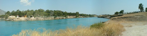
Panoramic view of the area of Cenchreai
Kenchreai flourished during the Roman Empire, when the settlement was focused around the crescent-shaped harbor enclosed by massive concrete breakwaters and protected by sea-walls. The local community was small but prosperous, and it was distinguished by its social, cultural, and religious diversity. Ancient literature and inscriptions from the site attest to the presence of cults of Aphrodite, Isis, Asklepios, Poseidon, Dionysos, and Pan. Christianity also arrived at Kenchreai early in the religion's history. According to acts 18:18, the Apostle Paul stopped at Kenchreai during his second missionary journey, where he had his hair cut to fulfill a vow. He mentions the place and a deaconess named Phoebe in the local assembly in his epistle to the Romans . A later ecclesiastical tradition recorded the existence of a bishop at Kenchreai, but the veracity of these accounts is hard to establish.
the ancient harbor
The ancient harbor was partly excavated in 1962-1969 by a team sponsored by the American school of classical studies under the general direction of Professor Robert Scranton. Excavations have uncovered several buildings that attest to the commercial vitality of the port throughout the Roman Empire and into the 7th century, when maritime activity and local habitation apparently diminished. The most impressive buildings located at the north and south ends of the harbor include blocks of rooms near the waterfront (probably warehouses); fishtanks; monumental complexes decorated with sculpted marble, mosaic pavements, and wall-painting (either sacred structures, lavish seaside villas, or rich public benefactions); and a small Christian basilica.=
Since 2002, survey and excavation jointly sponsored by the American School and the Greek Ministry of Culture has explored the area immediately north of the harbor on the low coastal ridge called Koutsongila. These new investigations have concentrated on a vast cemetery of Early Roman chamber tombs and Roman to Early Byzantine cist graves, an opulent residential quarter facing seaward, and other large structures overlooking the harbor. The bountiful artifacts and structures found both at the harbor and on Koutsongila reveal the considerable wealth of local residents, including several objects of exceptional artistic quality, and a connection to points of production and exchange to the east in the Aegean islands, Asia Minor, and the Near East.
Historical and geographical texts of the Byzantine and post-Byzantine eras indicate that Kenchreai was still used by travelers and Imperial expeditions. While the ancient harbor could still receive ship traffic after antiquity, the archaeological evidence for medieval occupation is thin, and any permanent settlement must have been smaller than in ancient times. A small harbor facility operated during early modern times, mostly serving to export local produce, including grains, citrus fruit, and tomatoes.
www.wikipedia.org


Saturday, May 17, 2008

N. Anhialos (Honouring my father's land)

The ruins of  Pyrasos


New Anchialos is located in Magnesia in Central Greece. 30 years before it was a small village but now it has become an almost small city.
N. Anchialos took its name from from the greek refugees who fled from the city Anchialos in 1906 when the bulgarian troops occupied the city.They chose the spcific site for their new home because it was a coastal place . N. Anchialos is built over the ruins of the ancient city of Pyrassos.
Everyone who visits the N. Anchialos can see the remnants of the old akropolis and many columns of themples of the Roman era.
Nowadays the small city is inhabited also by people who came from the surrounding villages
as there were many financial opportunities in a new society. The great development over the last years brought many tourists in the city. The coastal road is only for walkers and along there are many bars,clubs and coffeeshops. The sandy beach is big enough and the sea is clear.

Magnesia undoubtely offers us much better touristic spots like Pelion or the islands called Sporades.However i think that it would be right to show less advertised touristic spots.N.Anchialos is one of them. It's worth visiting

Thursday, March 27, 2008

Ακροκορινθος-Akrokorinth.


Korinth is only 100kms away from Athens.
You can take a bus or rent a car in order to reach Akrokorinthos.Akrokorinthos is an archaeological sight situated near the village of ancient Corinth and the modern city Korinthos.
You can see there the notorious Apollo temple , you can climb the hill and see the fortifications and the ruins of buildings of different ages(Roman,medieval,Turkish).
Near Akrokorinth, for those who get bored with archaeological sights , there are many beautiful beaches at the nearby coastal region like Kiato, xilokastro and diminio.At summer these touristic spots have an active nightlife as also does Korinthos.
Well let me return to the main subject. Akrokorinth isn't advertised so much by the greek ministry of tourism .Nevertheless it is a worth seeing archaelogical sight.
Akrokorinthos is near my home so that's why i begin my blog with it. Historically Akrokorinthos was the place where ancient Corinth was founded and expanded. The great hill served as a protection from enemy invasions. Every greek city in the past had an acropolis(hilltop castles).Gradually these hilltops served also as spiritual areas with the construction of temples dedicated to the protector god of the city.


put your country on top

free counters